Call 01 414 9000
Updates / May 07, 2019
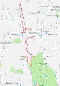
As part of the progression of the Whitechurch Stream FAS, Murphy Surveys Ltd, on behalf of SDCC and the OPW, will be carrying out a Topographic Survey of the Whitechurch Stream Catchment area from St Enda’s Park to its conflux with the Owendoher River.
Topographic Surveying is a simple operation which valuably assists in designing the most effective defences possible and greatly aids us in ensuring that your property is protected from a 1 in 100 year flood event similar to the event recorded on October 2011.
The survey involves the recording of the location and heights of the surface terrain features along the course of the Whitechurch Stream which includes Culverts, Bridges, Boundary Walls, Open Spaces and Service Utilities.
In most cases the information that needs to be recorded is on public lands but due to the boundary conditions of some areas along the stream, brief access to private property will be required to record the location and heights of boundary walls, fences etc. This is where we are seeking your assistance by allowing brief access to your property where it possess a boundary that borders onto the stream.
Notification Letters will be issued to properties where access will be required and all surveyors will carry identification badges.
The current schedule for the surveys is as follows;
07/05/2019 – 17/05/2019 – Topographic Surveys
04/06/2019 – 20/06/2019 – Utility Surveys
MAP OF SURVEY AREAS
If you have any queries please contact David Grant, Project Resident Engineer at 086-0211451 or at dgrant@sdublincoco.ie and info@whitechurchfas.ie